Outback Way-Finder Geocache Trail
What is geocaching?
Geocaching is now an international phenomenon. It was introduced to the world in 2000 and combines GPS technology, a quest, the great outdoors and individuals, couples, groups and families armed with a GPS loaded with a series of latitude and longitude coordinates.
The aim of the Outback Way-Finder Geocache Trail is to encourage travellers to stop, get out of their cars, search for a cache, enjoy the diversity of central Australia's landscapes, and appreciate the natural wonders. Some travellers may be happy to search for the occasional cache. On the other hand, some travellers along the Outback Way may be challenged by trying to find all 34 caches. Other travellers may prefer to stop at some of the more scenic sites and enjoy the thrill of finding a cache whilst also enjoying a casual walk, sightseeing or a leisurely rest from driving. Some of the caches are placed in remarkable locations that offer truly life changing moments (e.g. a ridgetop where the panorama reveals the curvature of the earth across vast flood plains below). Other caches are easily accessed by people with disabilities.
What is the Outback Way?
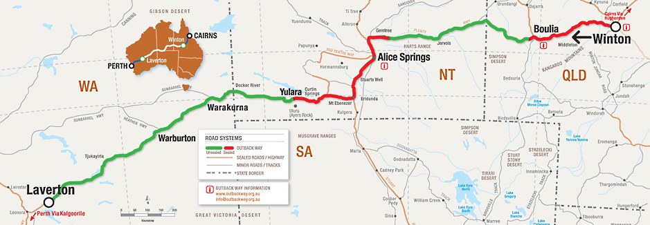
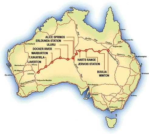
"The Outback Way" is a 2750km self-drive route from Laverton, WA to Winton QLD via central Australia (Ayers Rock, Alice Springs, MacDonnell Ranges) - shown in bold red on the map to the left. The Outback Way is being developed as an outback tourism travel experience by five shires that share a common road network. The route includes 1,800km of unsealed road (mostly sandy, corrugated, dual-lane track, suited to 4WD's) and 1,500km of sealed bitumen making the drive an experience of a lifetime (i.e. crossing deserts, remote regions, central Australian ranges, cattle country, fossicking/prospecting fields, flood plains-channel country, etc).
The Outback Way is currently being revamped as a self-drive tourist route with improved roadside infrastructure, promotion and visitor information. The Outback Way-Finder Geocache Trail comprises 34 hidden caches placed about 80km apart, extending for the entire 2,750km Outback Way. Travellers are invited to find each cache using handheld GPS (i.e. by searching for a given set of latitude/longitude coordinates). See next paragraph for more details on geocaching.
The improved visitor information includes a new website, Atlas and guidebook, brochure and route information portals at roadhouses, visitor centres and shire offices. The route currently has around 40,000 travellers / 18,000 vehicles per year and this is projected to increase by 10-15% annually.
You may want to purchase a handheld GPS to participate in the Way-finder trail.
What equipment is needed?
The most essential item for geocaching is a handheld GPS - preferably one that can withstand a few knocks, a few drops of rain, some dust and offers a few hours battery life. A list of the coordinates for caches along the Way-finder trail will be found at the official webpage when operational. The coordinates and descriptions for caches along the Outback Way will be listed on the official webpage (when operational). Both sets of data can be pre-loaded by Johnny Appleseed GPS when you purchase a GPS.
Johhny Appleseed & The Outback Way
The Outback Way is the brainchild of five outback shires extending across central Australia. The tourism project has been developed and implemented by a group of consultants who have delivered the 'means' to make the Outback Way more experiential, informative, adventurous, enjoyable and safer to travel. The Outback Way website is the primary source of information for travellers planning a trip along the Outback Way, as well as for travellers en route. To encourage travellers to enjoy the Way-finder Geocache trail, Johnny Appleseed GPS will pre-load all of the 34 cache points on any GPS sold.
Johnny Appleseed GPS will also pre-load the coordinates for the Way-finder trail PLUS 30-40 points of interest along the Outback Way such as parking bays, scenic sites, overnight campgrounds, interpretive panels and walk trails.


