dark

GPSMAP 66i vs InReach Explorer – What’s the difference and which is best for you


Garmin has released the GPSMAP 66i, which is the latest iteration of the GPSMAP series. It now includes 2-Way Satellite Communication while still retaining the GPSMAP functionality from the 66 series. The GPSMAP 66i is available in Australia now at an RRP of $899 AUD.

GPSMAP 66i comes with the following:

GPSMAP 66i | Access to BirdsEye Satellite Imagery (no subscription required) |USB Charger/Data Cable | Carabiner Clip | Manual and Documentation

The Quick Review: GPSMAP 66i vs inReach Explorer+ (Differences Only)

The Garmin inReach Explorer is a 2-Way satellite communicator capable of sending and receiving texts to any number or email in the world. The GPSMAP 66i shares this functionality but adds a stronger focus on mapping features as shown below.

GPSMAP 66i inReach Explorer+
Memory Capacity 16 GB 2 GB
Ability to add Custom Maps Yes No
Battery Life Up to 35 hours at 10-minute tracking

Up to 200 hours at 30-minute tracking (power saver mode)

Up to 100 hours at 10-minute tracking

Up to75 hours at 10-minute tracking with 1-second logging

Up to 30 days at 30-minute interval power save mode

Interface USB and NMEA 0183 compatible USB
Preloaded Maps Garmin Topo Active Mapping DeLorme (Open Street Maps)
Micro SD card Yes (not included) No
Area Calculation Yes No
Auto Routing  (turn-by-turn) Yes No
Geocaching Yes No
Garmin Connect Yes No
Birds Eye Satellite Imagery Yes No
RINEX Logging Yes No
GPSMAP 66i (left) and inReach Explorer+ (right)

Above are the core differences between the models. This isn’t a full feature list as both these units share a lot in common and I’ll be taking a deeper dive into their features later on.

As you would have concluded from the above table, the inReach Explorer+ has more of a focus on battery life performance and less on mapping functionality. This is because the inReach was primarily developed by DeLorme before Garmin acquired them. The GPSMAP 66i is closest to a full Garmin Satellite Communicator as it’s almost entirely a standard GPSMAP 66 with Satellite communication technology built-in.

The benefits and features of each device make it pretty clear which item is best. The GPSMAP 66i is your, do everything device when you’re off the grid. You can use this device with custom maps, a much more robust waypoint, route and log system along with more detailed topo maps. You also have access to auto-routing function for turn-by-turn navigation and satellite imagery for highly accurate mapping information.

On the other hand, if you prioritise battery life and are only really looking for a device with satellite communication capabilities and more straightforward location tracking, then the inReach Explorer+ is the best option as it’s designed to last much longer than the GPSMAP 66i. You lose custom mapping and other special features for this battery life, though.

There’s no difference in terms of satellite communication functionality. Both devices use the Iridium network, have the same high-sensitivity receiver, and incur the same subscription costs.

What does the Garmin GPSMAP 66i do?

The GPSMAP 66i is designed with the whole kit and caboodle. I’ll break its features and functionality down across the following sections:

  • Design and hardware 
  • Mapping
  • Satellite functionality and subscription costs
  • Outdoor features and sensors 
  • Smart features 
  • Accessories
GPSMAP 66i Main Menu
GPSMAP 66i - Measurement/Sensor Detail Page
GPSMAP 66i - Satellite Network Connections

Design and Hardware

GPSMAP 66i - Side Profile

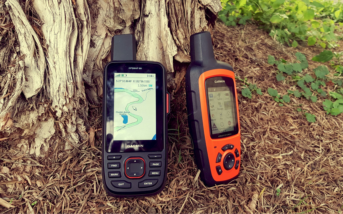
The GPSMAP 66i has a larger display screen than the inReach Explorer+ and comes with more button options. It feels a little snappier than the inReach Explorer+ in terms of how fast you can move around the menu page and open different apps.

Other than that, the design is similar and the buttons serve similar functions with the GPSMAP having dedicated find and mark and page buttons while the inReach Explorer+ has the lightning button for a designated shortcut function.
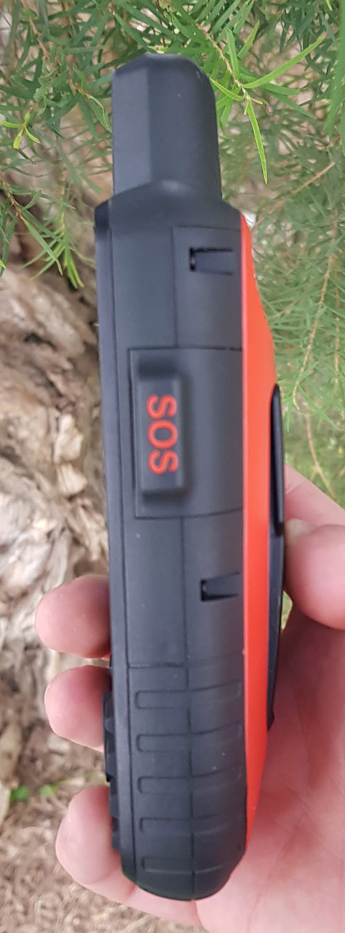
They both also have an SOS plastic button cover that hides the real button underneath to prevent any accidental SOS activation.

The GPSMAP 66i, like the 66 models, comes with a MIL-STD 810G certificate, which is basically a U.S. military standard for how robust and survivable the device is. There’s a mammoth 804-page document out there that explains in excruciating detail what this means but, in short, the device must pass a series of stress and durability tests. This includes:

  • Drop resistance
  • Vibration resistance
  • Wind and rain resistance
  • Sand and dust resistance
  • Crash and shock resistance 
  • Fluid contamination resistance
  • Extreme temperature resistance
  • Salt fog resistance
  • Humidity resistance
  • High altitude pressure resistance

Simply put, this certificate is a clear means of determining that, yes, the GPSMAP 66i is reasonably tough.

Mapping Features

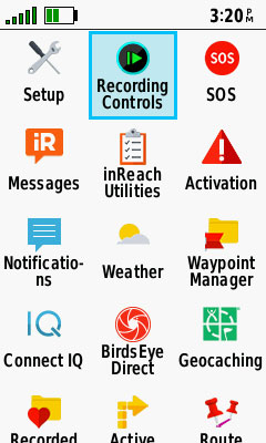
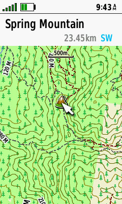
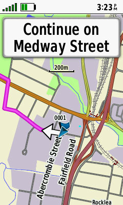
The GPSMAP 66i comes preloaded with routable Garmin Topo Active maps and access to BirdsEye satellite imagery (no subscription required). The Topo Active maps come with 2 free updates per year. These map updates are done via Garmin Express.

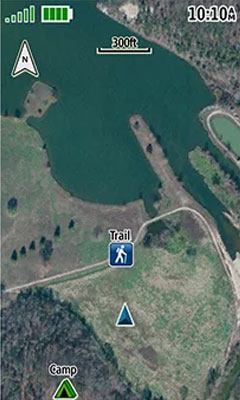
The GPSMAP 66i also has the option to add custom maps or maps via the SD card slot (alternatively, you can use this slot to increase the memory space of the device). The additional maps you can put on the device include Topo V6, Topo Lite, Hema map card or Hema Maps/Garmin maps. As it is technically part of the GPSMAP range, you can also add marine charts to the device if you’re headed out to open waters. This also means you can use the GPSMAP 66i with your standard Garmin software, such as BaseCamp. This will be a relief for a lot of users who are familiar with BaseCamp and have many of their tracks, routes and waypoints stored there.

You can also use the standard mapping features for GPSMAP devices including waypoints/favourites/locations (10,000 different points), 250 saved routes and 20,000 points on the track log, 250 saved GPS tracks, and 300 saved fit activities. Suffice it to say, you have extensive mapping options available through the GPSMAP 66i that are not possible on the Garmin inReach Explorer+.

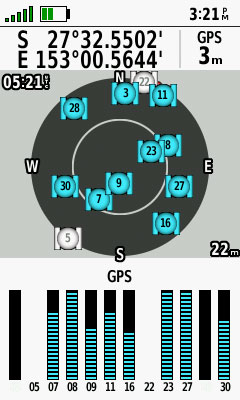
The GPSMAP 66 series also introduced the RINEX logging function. RINEX (Receiver Independent Exchange Format) allows for the recording of raw GPS data such as distance to satellites, line of sight speed between the receiver and satellite signal strength. This raw GPS data can be used with third-party programs to create more accurate locations, sometimes as precise as within 10cm of your actual location.

GPSMAP 66i - Topo Active Mapping Detail
GPSMAP 66i - Satellite Imagery
GPSMAP 66i - Topo Active Turn-By-Turn Routing

Satellite Functionality

The GPSMAP 66i uses the Iridium satellite network to send and receive text messages across the globe and in an emergency trigger an interactive SOS with 24/7 search and rescue monitoring. It’s important to note that this satellite function requires an active satellite subscription. With an active subscription, the GPSMAP 66i can message other 66i’s, inReach users, mobile numbers and email addresses.

*GPSMAP 66i GPS mapping features can function without an active subscription but you cannot: send/receive texts, share your current position live, request live weather updates

Another helpful feature is the ability to share your live position with friends, family, or anyone else you grant access to. This is done through Garmin’s MapShare, and tracking intervals will differ depending on the power mode your GPSMAP 66i is set at. Whoever you share your position with will be able to view your current position on the MapShare tracking page.

GPSMAP 66i - Satellite Activation Screen
GPSMAP 66i - SOS Emergency Response Example
GPSMAP 66i - Message Example

What are the subscription costs?

The table below outlines the subscription costs for the GPSMAP 66i Satellite subscription plan as of 2/07/19

  Safety Recreation Expedition Extreme Additional Fees
SOS Unlimited Unlimited Unlimited Unlimited
Text Messages 10 40 Unlimited Unlimited
Preset Messages Unlimited Unlimited Unlimited Unlimited
Tracking Intervals 10 Minutes+ 10 Minutes+ 10 Minutes+ 2 Minutes+
Tracking Points $0.15 Unlimited Unlimited Unlimited
Location Pings $0.15 Unlimited Unlimited Unlimited
MONTHLY CHARGES Activation Fee: $33.00
Annual/Contract $20.00 $40.00 $75.00 $119.00 Move Down A Plan Fee: $37.00
Freedom Plan $25.00 $55.00 $99.00 $149.00 Annual Freedom Fee: $37.00
OVERAGE CHARGES
Messages (each) $0.75 $0.75 N/A N/A

There are a lot of different prices and options on this so I’ll break it down.

Prices/Fees shared by both plan types (Annual and Freedom)

  • Activation fee $33

Annual/Contract Plan

  • This plan has cheaper monthly rates but requires you to sign on for at least 12 months
  • Moving down a plan tier on the Annual/Contract plan will incur a $37 fee

Freedom Plan

As the name suggests, the Freedom Plan offers you more flexibility than an annual plan, but the month-to-month cost is higher. A key benefit offered by its flexibility is that you can suspend and/or reactivate your plan at any point.

When you activate your device on this plan, you have 30 days of use before you’re automatically charged for the next month. You can suspend the subscription at any point before the next monthly charge whenever you don’t need to make use of satellite communications.

Plan Tiers

The features of each plan tier (Safety, Recreation, Expedition, or Extreme) are the same regardless of whether you’re on an annual contract plan or a Freedom plan, the only difference is the price you pay, with a higher month-to-month cost for Freedom.

What happens when you trigger an SOS?

When you open the flap on the side of the unit and press the button, the device will begin to trigger an SOS. The SOS button will automatically cancel in 5 seconds unless you explicitly acknowledge and proceed with the prompts on the screen. From there you will be put in contact with GEOS, a global monitoring and emergency response dispatch that operates in over 200 countries worldwide. Upon contact, they’ll begin arranging your rescue and asking you for details about your emergency.

Now, while this should be common knowledge, I think it’s still important to write about when it comes to triggering an SOS. You should only use SOS in a SERIOUS emergency - in other words, you should be at genuine risk if you don’t receive emergency help. A sore ankle and tummy ache won’t cut it. The emergency responders at GEOS risk their lives to rescue people and won’t appreciate you putting them in danger and taking resources away from others who might have been a higher priority. That said, if you are in grave danger, it’s comforting to know that help won’t be far away.

Outdoor Features and Sensors

The GPSMAP 66i offers area calculation, geocaching (paperless) and the aforementioned custom maps compatibility. It also has access to the standard GPSMAP features including the Hunt/Fish calendar, Sun and Moon information and the picture viewer function.

The GPSMAP 66i also comes with a barometric altimeter and a compass sensor (tilt-compensated 3-axis).

Smart Features

New to devices with inReach functionality, such as the GPSMAP 66i, is Garmin Connect compatibility. This allows you to add apps and special data fields made by Garmin’s community members.

The GPSMAP 66i also allows you to use the Garmin Explore app on your mobile phone. This app is a great companion to the 66i in that it helps you type messages on a familiar keyboard format, helps you conserve power and shows your map position without having to open the handheld.

Accessories

The GPSMAP 66i has several compatible accessories. It has a Garmin spine mount design, meaning it can be used with many Garmin accessories already. This includes RAM's spine mounts for use with all RAM mount products and Garmin's bike mount, backpack tether, belt clip, marine mount, lanyards and more. This doesn’t even go into its compatibility with compatible fitness sensors, Geocaching beacons, and heart rate monitors. To view the full list check out the ‘Accessories’ tab on this page.


GPSMAP 66i - Powered Mount Accessory
GPSMAP 66i - Marine Mount
GPSMAP-66i-Spine-Mount
GPSMAP 66i Spine Mount

Summary

Overall, the GPSMAP 66i shows itself to be a solid investment for your pack. The additional versatility of having extra mapping functions like custom maps, more room for waypoints and special mapping cards like marine maps or specialised maps like Hema Maps show that GPSMAP 66i is a solid 2-way Satellite messenger all-rounder. 

That’s not to say you need all these features. After all, if you just want a 2-way satellite messenger to keep your friends/family updated on your position and have the SOS option should you ever need it then a perfectly suitable option would be an inReach Mini. The inReach Explorer+ is also an option; but if you were deciding between a GPSMAP 66i or an inReach Explorer+ and the battery life wasn’t a factor, then I would go for a GPSMAP 66i.

1 comment
  1. I just bought a GPSMAP 66i from Garmin and I am really disappointed. As a safety tool it should never hang up, just like a lifejacket or a seat belt. Nevertheless, it does hang up. Imagine that happening when you are really in in distress.

    On top of that, it says that maximum message length is 160 characters. This was true for Garmin inReach+ previously. However, Garmin now defines message as not only the actual message but also the list of recipients. Long emails means that you have less characters. This is somewhat greedy to say the least. In practice, since this is a new thing, different recipients “cost” differently. My brother as a recipient sets me back just one character whereas my son sets me back 14 characters. It does not make sense.

    It would be great if you bring up these things so that Garmin is feels inclined to improve 🙂

Leave a Reply

Your email address will not be published. Required fields are marked *

Previous Post

New Garmin Dashcam 56, 66W, 46 and Mini Review

Next Post
forerunner-945-update

Forerunner 945 – Wrist-based heart rate for swimming (pool and open water)

Related Posts