With the release of the Garmin GPSMAP 66 series Bird’s Eye Satellite imagery has been moved from a paid subscription model to free access. This access is for GPSMAP 66 users only, and found in the main menu under the name Birds Eye Direct. Nothing has changed about the service, so there’s no advantage over the subscription-based model aside from it now being free.
This feature will allow you to download Hi-res Satellite images over a Wi-Fi or Bluetooth connection. These images are saved to the device and can then be displayed when viewing the map later (outside of Wi-Fi and Bluetooth access). This means you can save Satellite accurate images for offline use when you’re out on the trails.
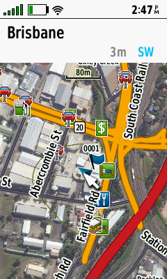
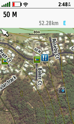
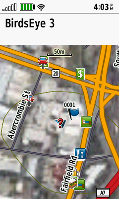
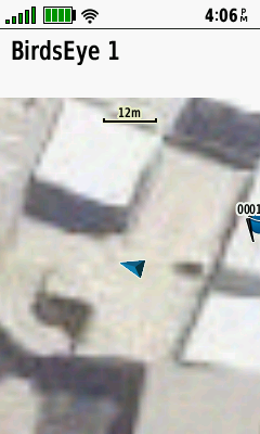
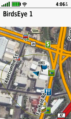
I’ve taken some screenshots below of what the Satellite images look like:
How to access Satellite images for Garmin GPSMAP 66
You can access the Satellite images via opening the main menu then selecting ‘Birds Eye Direct’ then simply choose download imagery.
At that point, you will be able to select the location of where you want to download the satellite image. You can select from a number of options here including finding a custom point on the map, waypoints you’ve saved, POIs. If you have a Garmin Topo Card installed you can take this much further with Addresses, Shopping, Lodging, Attractions and a bunch more.
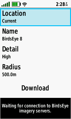

Once you’ve selected the location you can custom name the image. You also have the radius option, this determines the amount of area captured in the satellite image. Just as a note here increasing the radius can substantially increase the file size and download time.
Next you can select the level of detail, I’ll provide comparisons below of what difference this makes to the image:


Will my old devices now have free access to Bird’s Eye Satellite Imagery
Garmin has made no announcements about doing this and it seems to be pretty unlikely, given the cost to develop and license this change. The GPSMAP 66 is available for Pre-order now there are two separate models, the GPSMAP 66s and the GPSMAP 66ST. The only difference between the models is that the GPSMAP 66ST comes with Topographical maps preloaded. Garmin GPSMAP 66s - Compatible Accessories available in the Accessories tab on this page Garmin GPSMAP 66st - Compatible Accessories available in the Accessories tab on this pageSummary
The GPSMAP 66 is available for Pre-order now there are two separate models, the GPSMAP 66s and the GPSMAP 66ST. The only difference between the models is that the GPSMAP 66ST comes with Topographical maps preloaded.
Garmin GPSMAP 66s - Compatible Accessories available in the Accessories tab on this page
Garmin GPSMAP 66st - Compatible Accessories available in the Accessories tab on this page


how long duration for free access birdseye satellite imagery subscription?