Montana Series
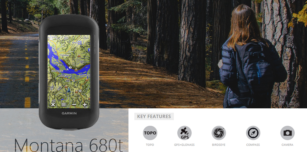
Whether you’re going on a hike, trekking through a desert, riding through rough bush trails or even out on the water the Montana 680t from Garmin can do it all. The Montana series of GPS units are Garmin’s flagship handheld when it comes to ruggedised and reliable positioning with the units boasting a large sunlight readable screen, high sensitivity receiver and a durable waterproof body. With its 8-megapixel camera and easy to use interface you’ll be able to effortlessly navigate to your destination and take some snaps along the way.
Montana 680t vs Montana 610
In the current Montana series there are two available versions; the premium version the Montana 680t and the basic version the Montana 610. There isn't a lot to talk about here, so I'll list the differences below:
- 8GB (Montana 680t) vs 4GB Montana 610
- Preloaded Full Topo Maps (Montana 680t) vs No maps Preloaded onto Montana 610 (You can buy the topo maps separately)
- 8MP Camera (Montana 680t) vs No camera on the Montana 610
This doesn't seem like a whole lot of difference between the units and it's not, but the price isn't also that different between the units. In fact, assuming you're going to want to buy a good Topo Maps solution which currently retails for $199 makes the Montana 680t ($899 RRP) the cheaper option. This is against the Montana 610 at $948 total ($749 RRP + $199 Topo Maps) and you get a camera on the Montana 680t.
Design and Hardware
With this iteration of the Montana line, Garmin has added a few more features to their already feature-packed handheld GPS while retaining their whole day battery life. The 680t is in its range as a direct upgrade from the 650t with a few new features and a few updates on the old ones to keep its place at the top of the pack.
The 680t has proven to be a very popular GPS of choice for adventure riding for this very reason as it is also a glove-friendly display so coupling that with its ruggedised and waterproof body you’ve got a GPS that can go anywhere the bike can.
Screen & Receiver
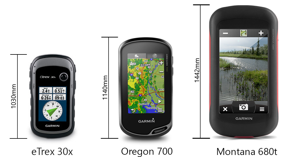
Returning from the earlier Montana models is their sunlight readable 4” TFT touchscreen which was a staple of the previous units. The addition of GLONASS support alongside the standard GPS receiver allows a faster and more precise acquisition of your position. It can also be helpful in areas with a weak signal or when you’re in a mountainous area or under tree cover making sure you’ve got as precise a fix as possible.
Storage
They have increased the internal storage from 3.5 GB on the 650t to 8 GB on the 680t, which is very handy affording you extra space to load more maps or tracks onto the device. Should you need more storage, you can expand that via a micro-SD card giving you up to another 32 GB of storage.
Montana Track Manager App
The 680t now has the Track Manager app pre-installed which makes accessing and managing any of your tracks quicker and easier. You can view all the metrics of your active track from total time to your total ascent and descent, as well as this you can also use the TracBack function to follow the path you’ve taken back to the origin point.
Compatible Maps
Whether you’re on a trail, on the road or out on the water Garmin, have a map for it, and the Montana 680t supports them. You could load all three onto a micro-SD card if you wanted to as all of the maps can be run in tandem so you can seamlessly transition between them. In the event you need even more detail, Garmin also has their BirdsEye satellite imagery service which can load high-resolution satellite images onto the unit, which can also run in tandem with the maps loaded onto the device.
The Montana 680t also comes with the Full Topo V5 maps for Australia and NZ. Just as a quick rundown on the advantage of full Topo maps, this will allow you to use the address search functionality, auto routing and more detailed topographical map features.
Camera
While not a new addition to the Montana line the camera has been upgraded. It is now sporting a higher resolution sensor that shoots your photos at 8 megapixels while still geo-tagging photos automatically.
Battery Life
The Montana 680t true to its line has retained its full-day battery life with the supplied rechargeable battery boasting 16 hours, however, if you do need more juice using 3 AA batteries you can squeeze another 6 hours out of it getting a 22-hour charge. This keeps it very comparable to the rest of Garmin’s handheld line only being outpaced by the eTrex range which boasts 25 hours maximum per charge which is of course due to the eTrex range being a more basic device.
Accessories
To assist with the multi-functionality of the device Garmin have made a lot of purpose-driven mounts for the Montana range. The first one is their auto suction mount which as you can see here gives you everything you need to get your GPS in position and power in a vehicle. It is worth noting though that you won’t be able to do any on-road navigating without the applicable CityNav map package for your country. Next one in the line-up we have is for mounting to a motorcycle or any bare wires compatible power source as you can see here this mount also has a 3.5mm socket for audio connections. If you’re on two wheels but prefer a non-powered approach, Garmin makes a handlebar mount for bicycles as seen here which tightens in place on the handlebars and has a moulded rubber cushion to help to grip the handlebars. Lastly, we have the marine mount which you can see here, this mount has the bare wire power connections and 3.5mm audio socket same as the motorcycle mount but has a screw down swivel mount.
Summary
With its large screen and uncompromising battery life the Montana range has been the go-to GPS in Garmin’s line up and the 680t is no different sporting substantial upgrades to its capabilities and existing functionality. This is what sets the Montana 680t aside from the other handheld units in Garmin’s range which are often targeted at one market or one feature; this unit does it all.
The primary usage for the Montana 680t is to be a handheld GPS however they have become a prevalent device for adventure bike riding. Having the ability to take the device out for a whole day ride without needing to swap batteries or have it plugged in to charge has proved to be a big selling point for the Montana edging out the purpose-built motorcycle units the Zumo series.
The biggest criticism for the Montana 680t is the size of the unit. It is quite a chunky device due to the size of its screen and its battery which while not oversized can be cumbersome if you intend to pack light for a trip.
Montana 680T vs Oregon 750t vs Etrex 30x| Oregon 750t | Montana 680t | eTrex 30x | |
|
General |
|||
|
Physical dimensions |
2.4″ x 4.5″ x 1.3″ (6.1 x 11.4 x 3.3 cm) | 2.9″ x 5.7″ x 1.4″ (7.48 x 14.42 x 3.64 cm) | 2.1″ x 4.0″ x 1.3″ (5.4 x 10.3 x 3.3 cm) |
| Weight | 7.4 oz (209.8 g) with batteries | 10.2 oz (289 g) with included lithium-ion battery pack; 11.7 oz (333 g) with 3 AA batteries (not included) | 5 oz (141.7 g) with batteries |
| Water rating | IPX7 | IPX7 | IPX7 |
| Battery | rechargeable NiMH pack (included) or 2 AA batteries (not included); NiMH or Lithium recommended | rechargeable lithium-ion (included) or 3 AA batteries (not included); NiMH or Lithium recommended | 2 AA batteries (not included); NiMH or Lithium recommended |
| Touchscreen | Yes | Yes | No |
| Display type | transflective color TFT touchscreen | bright, transflective 65k color TFT, dual-orientation touchscreen; sunlight readable | 2.2″ transflective, 65K color TFT |
| Display size | 1.5″W x 2.5″H (3.8 x 6.3 cm); 3″ diag (7.6 cm) | 2″W x 3.5″H (5.06 x 8.93 cm); 4″ diag (10.2 cm) | 1.4″ x 1.7″ (3.5 x 4.4 cm); 2.2″ diag (5.6 cm) |
| Display resolution | 240 x 400 pixels | 272 x 480 pixels | 240 x 320 pixels |
| Battery life | up to 16 hours | up to 16 hours (lithium-ion); up to 22 hours (AA batteries) | 25 hours |
| Memory/History | 4 GB | 8 GB | 3.7GB |
| High-sensitivity receiver | Yes | Yes | Yes |
| Interface | high-speed USB and NMEA 0183 compatible | high-speed USB and NMEA 0183 compatible | USB |
|
Maps & Memory |
|||
|
Ability to add maps |
Yes | Yes | Yes |
| Basemap | Yes | Yes | Yes |
| Storage and Power Capacity | microSD™ card up to 32 GB (not included) | microSD™ card (not included) | microSD™ card (not included) |
| Waypoints/favorites/locations | 10,000 | 4000 | 2000 |
| Routes | 250 | 200 | 200 |
| Track log | 20,000 points, 250 saved tracks | 10,000 points, 200 saved tracks | 10,000 points, 200 saved tracks |
| Preloaded maps | yes (TOPO Lite) | yes (TOPO Full) | |
|
Sensors |
|||
|
Barometric altimeter |
Yes | Yes | Yes |
| Compass | Yes (tilt-compensated 3-axis) | Yes (tilt-compensated 3-axis) | |
|
Outdoor Recreation Features |
|||
|
Area calculation |
Yes | Yes | Yes |
| Automatic routing (turn by turn routing on roads) | Yes (with optional mapping for detailed roads) | Yes (with optional mapping for detailed roads) | Yes (with optional mapping for detailed roads) |
| Geocaching-friendly | Yes (Paperless) | Yes (Paperless) | Yes (Paperless) |
| Custom maps compatible | Yes | Yes | Yes |
| Hunt/fish calendar | Yes | Yes | No |
| Sun and moon information | Yes | Yes | Yes |
| Camera | yes (8 megapixel with autofocus; digital zoom) | yes (8 megapixel with autofocus; automatic geo-tagging) | |
| Picture viewer | Yes | Yes | Yes |
|
Garmin Connect™ |
|||
|
Garmin Connect™ compatible (online community where you analyze, categorize and share data) |
Yes | Yes | No |
|
Additional |
|||
|
Additional |
Wireless compatible: yes (Wi-Fi, Bluetooth and ANT+) | ||
| Map segments: 15,000 | |||
| Active weather: yes | |||
| Connect IQ compatible: yes (data fields) | |||
| Flashlight: yes |
How to Factory Reset a Montana 680t
To factory reset a Montana 680t you want to start with the device turned off, then press down and hold on the top left of the screen. After you’ve done this turn the device on while still holding the top left until the screen shows ‘Do you really want to erase all user data?’, You can then release the screen and tap ‘Erase’ to factory reset your device. Doing this will delete all your data such as waypoints and tracks, and the whole process will take about 20 minutes and is ideally done with the clear view of the sky.


