Contents
Garmin inReach Australian Release
It was January this year during CES 2017 that Garmin finally announced their new inReach products. We’ve waited a year since Garmin purchased DeLorme the original inReach creators for Garmin to put a product out. Strategically, Garmin’s decision to acquire DeLorme was primarily focused on locking down a previously untapped portion of their market that currently use or need SOS and two-way communication via Satellite network.
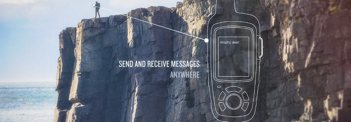
The new versions of the inReach products released are extremely similar in size, form and function to the older DeLorme models but now come with handheld GPS functionality. (DeLorme originally produced the InReach SE and the InReach Explorer) If you’re serious about hiking or going off the map then you’ve likely heard of them already but I’ll give a quick recap of their primary functions. The core functionality to provide a means of communication between you and rescuers/selected recipients that not only updates them on your status by chosen message but also your location.


Features and Specs
Each unit comes in either yellow (SE+) or orange (Explorer+) depending on which version you purchase. The InReach+ models are around the same size as a GPSmap 64. *Which is about the size of a can of coke as a more universal means of scale.
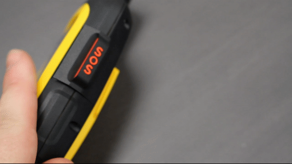
The new inReach models have dedicated SOS buttons which will, when triggered, alert GEOS rescue monitoring centre (24/7/365) and open a communication window with them. You will receive a confirmation alert as well when you trigger the SOS. Additionally, you can set up the inReach model to send a preformatted text to certain recipients should you trigger the SOS at any time. This means that when you’re in real danger you can rest assured that someone is coming to help you and if you’re capable, you can inform them of your situation to make sure they know exactly how to help as soon as they arrive.
*In case you’re as scared of bumping the S.O.S button as I would be, the ‘button’ on the side is a cover flap for the actual button underneath.
The messaging system with the inReach models is a little clunky in the way it types (using the arrow button to move around the virtual keyboard) but overall serves its function. You can also pair your inReach with your smartphone via the Earthmate App for easier typing. There is a whole range of uses for messaging in the wilderness beside the obvious rescue scenario. You may have busted a tire on your bike and need to let the group know you’ll be 30 minutes late, you might be on a cliff edge inspired by the natural beauty around you and have the sudden, powerful urge to write a long stirring poem to someone special. It could happen, and with Garmin inReach, you would be ready for it.
Additionally, the inReach messaging system does feature predictive text as navigating the screen keyboard with the arrow keys could be a little cumbersome if you have meaty thumbs like myself.


GPS Features and inReach benefits
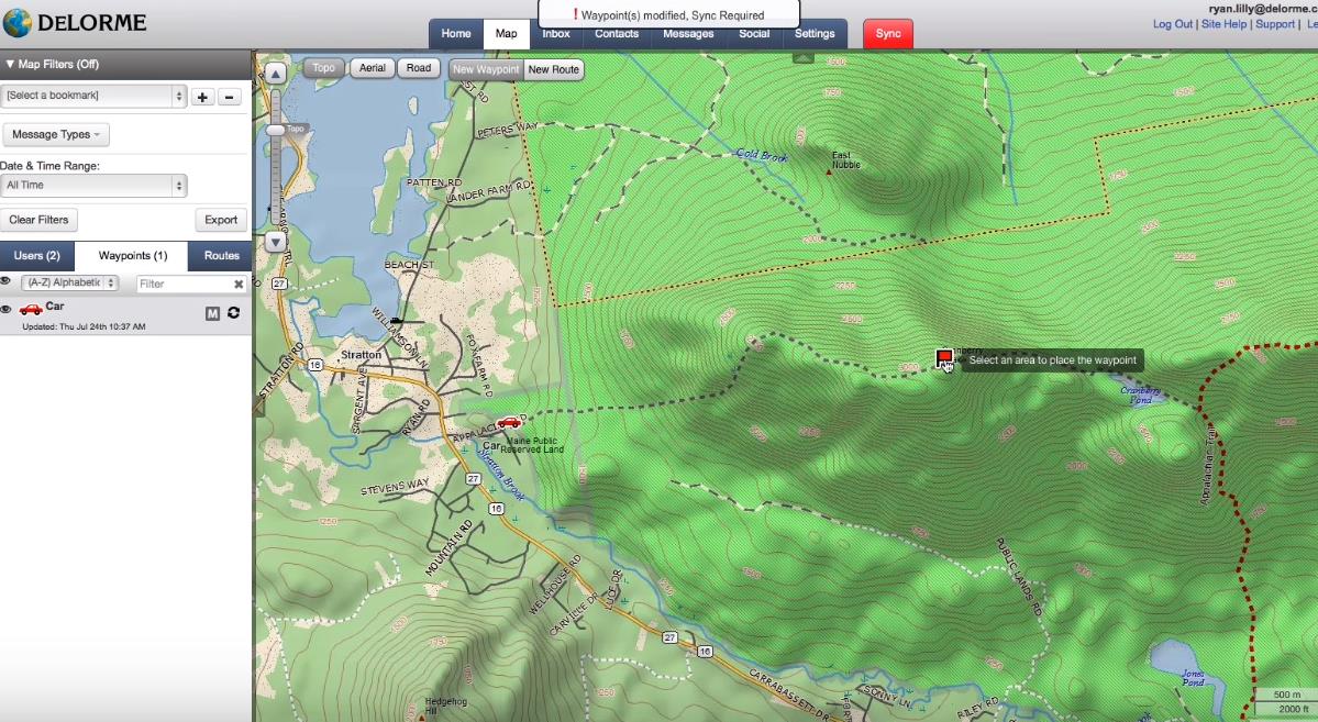
Purchasing any inReach device gains you access to a free cloud-powered portal to plan your trip with routes and waypoints. The inReach models also include unlimited cloud storage and trip planning with the portal. Both devices function as a handheld GPS with basic features including navigation, location and tracking data.
In Reach SE+
- SE+ uses GPS to provide basic grid navigation and allows you to drop waypoints, mark key locations and track your progress as well as a breadcrumb trail to lead you back to base.
In Reach Explorer+
- Explorer+ provides full-fledged GPS with on-map guidance and preloaded TOPO mapping and waypoint routeing viewable directly on the unit. The Explorer+ unit also comes with a digital compass, barometric altimeter and accelerometer. Both devices pair with the Earthmate app for additional map data.
Subscription Service
As these devices leverage the same Satellite network as most Satellite Phones it’s unsurprising that they have a subscription plan to accommodate your use. Depending on the subscription service you choose you will be able to set how many texts you want to send/receive (10, 40, unlimited) and how frequently the system will update your tracking point ‘breadcrumb’1. They give the option of month by month or annual subscription billing.
All inReach devices communicate via the Iridium Satellite network which provides 100% global coverage. They don’t rely on traditional cellular networks which are what makes them handy when you’re in a critical situation in an area with little to no cellular coverage. Meaning you’re able to stay in two-way communication to keep emergency crews aware and up to date on your status.
|
|
Recreation |
Expedition |
Extreme |
Additional Fees |
|
|
SOS |
Unlimited |
Unlimited |
Unlimited |
Unlimited |
|
|
Text Messages |
10 |
40 |
Unlimited |
Unlimited |
|
|
Preset Messages |
Unlimited |
Unlimited |
Unlimited |
Unlimited |
|
|
Tracking Intervals |
10 Minutes+ |
10 Minutes+ |
10 Minutes+ |
2 Minutes+ |
|
|
Tracking Points |
$0.15 |
Unlimited |
Unlimited |
Unlimited |
|
|
Location Pings |
$0.15 |
Unlimited |
Unlimited |
Unlimited |
|
|
MONTHLY CHARGES |
Activation Fee: $33.00 |
||||
|
Annual/Contract |
$20.00 |
$40.00 |
$75.00 |
$119.00 |
Move Down A Plan Fee: $37.00 |
|
Freedom Plan |
$25.00 |
$55.00 |
$99.00 |
$149.00 |
Annual Freedom Fee: $37.00 |
|
OVERAGE CHARGES |
|||||
|
Messages (each) |
$0.75 |
$0.75 |
N/A |
N/A |
|
*These charges need to be paid online to Garmin directly not the Retailer and are subject to change
Battery and Rugged capability
Both models have protective casings for rugged use and are waterproof to a rating of IPX7. This means the device is rated for 1m submersion up to 30 minutes [We have a full breakdown of Garmin’s waterproof rating system here]. Garmin has suggested 4 days of battery life (roughly 100 hours) in tracking mode (Tracking mode sending a breadcrumb every 10 minutes) and up to 30 days in power saver mode (disables everything on the unit except for tracking mode which breadcrumbs every 30 minutes). I mentioned previously the possibility of using this device as both a handheld GPS and your Satellite Messenger – If you plan to the inReach models like this keep in mind the battery life will be significantly reduced.
I’ve listed all the product features below and compared the current and original models *The pricing below is valid at the time of publication and may change
|
Features |
DeLorme inReach SE ($544) |
DeLorme inReach Explorer ($639) |
Garmin inReach Se+ ($599) |
Garmin inReach Explorer + ($699) |
|
Waterproof rating |
IPX67 |
IPX67 |
IPX7 |
IPX7 |
|
Dimensions (mm) |
(W)62x(H)26x(L)149 |
(W)63x(H)34x(L)148 |
(W)68x(H)47x(L)164 |
(W)68x(H)38x(L)164 |
|
Weight (grams) |
190 |
190 |
213 |
213 |
|
Digital compass |
- |
Yes |
- |
Yes |
|
Barometric altimeter |
- |
Yes |
- |
Yes |
|
Accelerometer |
- |
Yes |
- |
Yes |
|
Memory for maps (GB) |
- |
- |
- |
2 |
|
Waypoints |
- |
Yes |
Yes |
Yes |
|
Routing |
- |
Yes |
Yes |
Yes |
|
Preloaded topographic maps |
- |
- |
- |
Yes |
|
100% global satellite coverage with Iridium™ |
Yes |
Yes |
Yes |
Yes |
|
Two-way global interactive SOS |
Yes |
Yes |
Yes |
Yes |
|
Tracking and location sharing |
Yes |
Yes |
Yes |
Yes |
|
Cloud storage and trip planning |
Yes |
Yes |
Yes |
Yes |
|
Pairs with mobile devices |
Yes |
Yes |
Yes |
Yes |
|
Navigation (routes, waypoints, breadcrumb trail) |
Yes |
Yes |
Yes |
Yes |
|
Weather |
Yes |
Yes |
Yes |
Yes |
inReach Business use
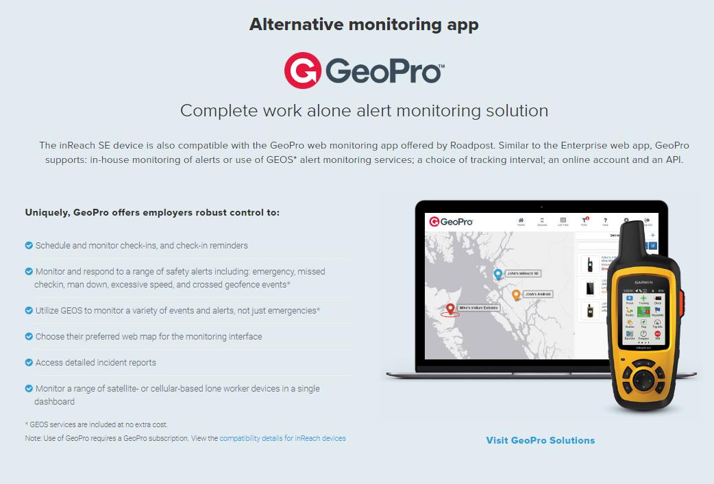
The inReach systems are well known for their recreational use but they also have various business capabilities. Specifically, for lone worker monitoring and even team tracking networks. InReach has their own in-house enterprise system available as well as third parties such as GeoPro *GeoPro is not available in Australia. The business system side of inReach is geared towards constant team tracking via one central location. Administrator/s can ping any user on their network for an immediate status update or field report. The Enterprise system also allows for messaging to the entire team in addition to individual messaging. They also incorporate the ability to set tracking intervals between 30 seconds up to 4 hours.

Summary
Looking at both products and the price difference between them $100 the real question you need to ask is whether you have a handheld GPS already or other GPS solution? It’s quite handy to have a two-in-one device that does both communication and GPS tracking but will come at a significant cost to the battery.
1 Breadcrumb refers to the data points left on your GPS map at your chosen time intervals


Have you actually used this new model here in Australia ? Is the satellite text messaging laggy?
I haven’t used a registered version of the device personally but a customer we’ve dealt with reviewed the product and talked about the response time delay specifically. In his words, the time response was “reasonable considering it was using Satellites”. I would say you can expect some time delay between messages. https://www.ja-gps.com.au/Garmin/inreach-se-plus/ You can also check the reviews on the Explorer+ model as well.
Just an update on this comment I’ve purchased and used an inReach Explorer+ reguarly now for a couple of months and can confirm their is about a 3 minute delay in ‘Optimal Satellite’ (clear of view of the sky and much wood bouncing the signal around). In other conditions it can take a bit longer which varies on where how strong your signal is.